


Image 8-4
Africa & Middle East
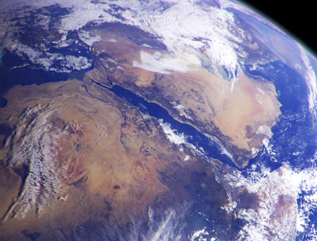
This image of northeast Africa and the Arabian Peninsula was taken from an altitude of about 300,000 miles (500,000 km) by the Galileo spacecraft on December 9, 1992, as it left Earth on its way to Jupiter. Visible in the image are most of Egypt (left of center), including the Nile Valley; the Red Sea (slightly above center); Israel; Jordan, and the Arabian Peninsula. In the center, below the coastal cloud, is Khartoum, at the confluence of the Blue Nile and the White Nile. Somalia (lower right) is partly covered by clouds.
NASA / JPL Image
Solar System | Faces of Mars | Visions of Jupiter | Sights of Saturn
Best of Hubble #1 | Best of Hubble #2 | Spitzer Spectacles | Above the Earth